
Dhamoirhat Upazila, Naogaon
 |
| Dhamoirhat Upazila Administrative Building within Upazila Parishad premises, 2024. |
Learn Details About Dhamoirhat Upazila
Dhamoirhat Upazila (Bangla: ধামইরহাট উপজেলা) is a northern upazila (sub-district) in Naogaon district. The upazila is surrounded by West Bengal (India) on the north, Badalgachhi and Patnitala upazilas on the south, Sapahar Upazila on the west and Joypurhat sadar upazila on the east. Historically, Dhamoirhat thana was founded in 1922 and was upgraded into an upazila in 1983.

Administration
The Dhamoirhat upazila has eight union councils and one Pourashava (municipality). It has 245 villages and 215 mousaz.
Electoral Area: 47, Naogaon-2 (Patnitala and Dhamoirhat Upazila)
List of Union Parishads in Dhamoirhat Upazila
Dhamoirhat has a total of 8 union parishads (councils). The names of the unions are:
- Agradigun Union
- Alampur Union
- Aranagar Union
- Dhamoirhat Union
- Isabpur Union
- Jahanpur Union
- Khelna Union
- Umar Union
See a full list of Union Parishads in Naogaon District.


Population in Dhamoirhat Upazila, Naogaon
Based on the 2022 census,1 the present population in Dhamoirhat Upazila is 194,181. Of these, 170,182 live in rural areas and 23,999 live in urban areas. The upazila’s gender ratio is 100.32. Annual population growth rate is 0.44%. The upazila has 1.50% of disabled population.
Population by Religion
| Religion | Population | Percentage (%) |
|---|---|---|
| Muslim | 169,348 | 87.21% |
| Hindu | 14,908 | 7.68% |
| Christian | 6,622 | 3.41% |
| Buddhist | 31 | 0.02% |
| Others | 3,272 | 1.68% |
| Dhamoirhat (total) | 194,181 | 100.00% |
In Dhamoirhat Upazila of Naogaon, Muslims are the largest religious group at 87.21%. Hindus are the second-largest community, representing 7.68%. The third religious group is Christians and they represent 3.41%. Buddhists and “Others” account for smaller portions, 0.02% and 1.68% respectively.
Ethnic Population
| Ethnic Group | Total Population | Male | Female |
|---|---|---|---|
| Bagdi | 1 | 0 | 1 |
| Barman | 452 | 234 | 218 |
| Bedia | 300 | 156 | 144 |
| Bhuimali | 13 | 6 | 7 |
| Bhumij | 4 | 2 | 2 |
| Bom | 1 | 0 | 1 |
| Chakma | 1 | 0 | 1 |
| Garo | 1 | 0 | 1 |
| Gonju | 726 | 352 | 374 |
| Gorait | 2 | 1 | 1 |
| Hajong | 1 | 1 | 0 |
| Ho | 1 | 0 | 1 |
| Hudi | 1 | 1 | 0 |
| Kharia/Khadria | 66 | 33 | 33 |
| Koch | 33 | 16 | 17 |
| Kol | 1 | 0 | 1 |
| Kora | 21 | 12 | 9 |
| Lohar | 2 | 1 | 1 |
| Mahali | 282 | 140 | 142 |
| Mahato/Kurmi Mahato/Bedia Mahato | 298 | 157 | 141 |
| Malo/Ghasimalo | 107 | 52 | 55 |
| Marma | 7 | 4 | 3 |
| Munda | 2,392 | 1,151 | 1,241 |
| Mushor | 5 | 2 | 3 |
| Oraon | 1,800 | 905 | 895 |
| Others | 800 | 374 | 426 |
| Rakhain | 2 | 1 | 1 |
| Saontal | 4,834 | 2,404 | 2,430 |
| Shobor | 1 | 0 | 1 |
| Tripura | 1 | 0 | 1 |
| Upazila Total | 12,156 | 6,005 | 6,151 |
The total ethnic population in Dhamoirhat Upazila is 12,156, with a near-balanced gender distribution: 6,005 males and 6,151 females. The largest ethnic group is the Saontal (4,834). The second-largest is the Munda (2,392). Other groups have much smaller representation.
See full statistics on ethnic population across the Naogaon district.
Household
The upazila has a total of 54,704 households. Of these, 48,225 are in rural areas, and 6,479 are in urban areas. Average household size is 3.52 persons.
Education
Type of educational institute and its count across the upazila is listed below.2
| Institution Type | Number |
|---|---|
| Government Primary School | 64 |
| Non-Government Primary School | 41 |
| Community Primary School | 03 |
| Junior High School | 04 |
| High School (Co-Education) | 23 |
| High School (Girls) | 03 |
| Dakhil Madrasa | 16 |
| Alim Madrasa | 03 |
| Fazil Madrasa | 04 |
| Kamil Madrasa | 01 |
| College (Co-Education) | 06 |
| College (Female) | 01 |
 |
| Dhamoirhat Government M. M. College in Dhamoirhat upazila town, Naogaon – 2024. |
Literacy in Dhamoirhat Upazila
As per the 2022 census, the literacy rate in Dhamoirhat upazila is 72.95%. Male literacy rate is 74.32% and Female literacy rate is 71.57%.
Archaeological Site in Dhamoirhat Upazila
- Jagaddal Maha Bihar – জগদ্দল মহা বিহার.
- Altadighi National Park – আলতাদীঘি জাতীয় উদ্যান
- Bimer Panti – ভীমের পানটি
- Mahishontosh Mazar – মাহিসন্তোষ মাজার
Marks of War of Liberation
The upazila has two mass graves: one in Farsipara and another in Pagla Dewan area.
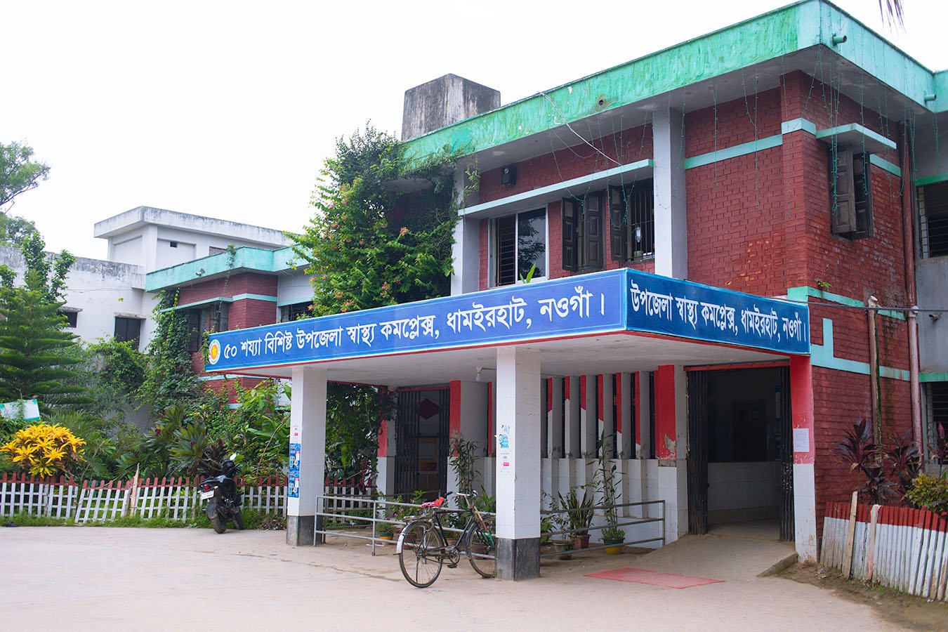
Healthcare in Dhamoirhat
Dhamoirhat has one Health Complex with 50 beds in the town, serving as the main medical center. Additionally, five Upazila Health and Family Welfare Centers provide healthcare across the upazila.
Currently there are 28 sanctioned doctor positions; however, only 5 doctors are actively serving in the upazila. The team also includes 9 senior nurses and 1 assistant nurse.3
Local Resources and Facilities
- Haat/Bazaar (Market): 20
- Government-Owned Ponds: 499
- Private Ponds: 1,808
- Government Water Bodies: 4 (Satbil, Kanchanbil, Ghukshibil, Kokilbil)
- Rivers: 2 (Chhoto Jamuna and Atrai)
- Mosques: 293
- Temples: 15
- Churches: 5
- BGB Camps (Border Guard Bangladesh): 6 (Kalupara, Chakilam, Chakchandi, Bostabar, Chakshimultoli, Talonda)
- Arable Land: 58,925 acres / 23,856 hectares
- Registered Kazis (Marriage Registrars): 94
References and Footnotes
- Population and Housing Census 2022, District Report – Naogaon
- Dhamoirhat at a Glance – Upazila Portal
- Dhamoirhat at a Glance – Upazila Portal
- Dhamoirhat Upazila at a Glance – BBS – Dhamoirhat

_Bangladesh.svg.png)


%2Bcopy.jpg)
